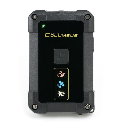


Columbus
Columbus P-10 Pro Submeter (0.5m) GPS/GNSS Data Logger and USB Receiver
Columbus P-10 Pro Submeter (0.5m) GPS/GNSS Data Logger and USB Receiver
Country of Origin: China
Couldn't load pickup availability
You might guess this is a RTK base GPS Logger. No, it is NOT.
Instead, Columbus P-10 Pro uses the most advanced dual-frequency(L1 and L5 bands) positioning technology, which increases the positioning accuracy by 5 times. It reaches the sub-meter level accuracy without compromising the cost of ownership. For the first time, low cost and ultra-high-precision position logging become possible!
GNSS products are widely used, but the single-frequency L1 products have a bottleneck: low positioning accuracy that is difficult to improve.
The new L5 frequency has come as a response to the shortcomings of single-frequency L1 and demands for higher positioning!
Multi-constellation positioning capability
GNSS stands for Global Navigation Satellite System.
P-10 Pro supports multi-constellation in the world: GPS L1 and L5; GLONASS L1; Galileo E1 and E5a; BeiDou B1; QZSS L1 and L5; IRNSS L5.
Compared with the single-constellation GPS positioning system, the GNSS multi-constellation positioning system can ensure rapid and effective positioning at any location in the world, while improving positioning accuracy and reliability.

What is dual-frequency L1+L5?
Dual-frequency L1+L5 positioning refers to a technology that uses both the L1 frequency and the L5/E5a frequency of the GNSS system.
The frequency of the L1 band is 1575MHz, and the figure for L5 band is 1176MHz. The wavelength of L5 is longer, and the attenuation during transmission is smaller. The signal strength of L5 is 6dB (4 times), higher than that of L1, while the chip rate of L5 (10.23MHz) is 10 times that of L1, and the ranging accuracy is also increased tenfold.
P-10 Pro is equipped with dual-frequency L1+L5 and built-in L1+L5 dual antennas. Compared with single-frequency GPS products, it has its positioning accuracy improved from 2.5 meters to 0.5 meters.
Among the professional data loggers, P-10 Pro is the first to achieve sub-meter positioning accuracy.

Effectively eliminate Ionospheric and multipath interference
Compared with single-frequency, dual-frequency can effectively eliminate ionospheric errors and counter multipath effects, both of which are major factors behind errors in GNSS positioning accuracy.
P-10 Pro, which supports dual-frequency L1+L5, can simultaneously monitor signals on two different frequencies on the same satellite, compare and analyze the data, and correct ionospheric delay to eliminate errors caused by the atmosphere.
In challenging environments (such as urban canyons, high-rise buildings and places covered by trees), satellite signals become messy after being reflected by buildings and intertwined with the correct direct signals, and the equipment has a large positioning accuracy error in this case, i.e. the multipath effect. Dual-frequency technology can distinguish the real signal from the signal reflected by the building, thereby reducing errors caused by multipath effects.

“Overall, the multi-constellation, dual-frequency receiver provided more robust and accurate positional solutions compared with single-frequency smartphones.”*
* Julián Tomaštík, Juliána Chudá, Daniel Tunák, František Chudý, Miroslav Kardoš, Advances in smartphone positioning in forests: dual-frequency receivers and raw GNSS data, Forestry: An International Journal of Forest Research, Volume 94, Issue 2, April 2021, Pages 292–310
P-10 Pro is an epoch-making HD GNSS data logger.
It can achieve lane-level positioning accuracy in the open air, and boasts a number of excellent anti-interference abilities in a challenging environment.
P-10 Pro is more stable, more accurate, more professional!
What does the HD GNSS of P-10 Pro refer to?
High Definition Global Navigation Satellite System. It refers to the high-precision positioning performance that P-10 Pro can provide: Horizontal direction 0.5m/CEP(50%); 1.5m/CEP(95%). It boasts lane-level positioning accuracy.
CEP refers to Circular Error Probable. 0.5m/CEP(50%)* means that the probability of the track points falling within a 0.5m radius is greater than 50%; 1.5m/CEP(95%)* means that the probability of the track points falling within a 1.5m radius is greater than 95% .
P-10 Pro also has high absolute altitude accuracy with an error of only ±15 m *, comparable to the altitude measurement ability of a barometer.
*Data from testing in ideal open environments

Static drift test
Test purpose: To evaluate the static drift suppression performance of the receiver (P-10 Pro config file parameter: Speed mask=OFF).
Test duration: 4 hours
Location: On the roof of the building, P-10 Pro is placed face up, and the GNSS status lamp is blue.
Surroundings: In a 50m radius, there are no objects higher than above-mentioned location.

Walking track test
Test purpose: Walk around the outer circle of the tennis court and return to the start point to evaluate the accuracy of the track at an ultra-low speed.
Test time: UTC 2021-10-20 15:23 | Average speed: 3.5km/h
Location: P-10 Pro is held in hand, face up, with a certain distance from the body, and the GNSS status lamp is blue.
Surroundings: Open sky, with no buildings blocking the vision nearby.

Low-speed driving track test
Test purpose: Record three consecutive times along the same route to evaluate the smoothness of the low-speed driving track.
Test time: UTC 2020-10-20 17:02~17:11 | Average speed: 5.5km/h
Location: Under the front windshield of the vehicle, P-10 Pro is placed face up, and the GNSS status lamp is blue.
Surroundings: Houses and trees are densely distributed nearby.

Driving test
Test purpose: On a two-way seven-lane road, record a different lane each time to evaluate whether the adjacent lane can be distinguished.
Test time: UTC 2020-10-20 17:31:37~17:41:36 | Average speed: 34km/h
Location: Under the front windshield of the vehicle, P-10 Pro is put face up, and the GNSS status lamp is blue.
Surroundings: Located on the main road in the urban area, with trees and buildings on both sides.

Altitude test
Test purpose: Record three consecutive laps around the same area. Check whether the highest point appears in the same position, evaluate the value of each highest point, and evaluate the uniformity of the height value. The actual height difference is only ten meters.
Test time: UTC 2020-10-20 17:14 | Average speed: 10km/h
Placement: Under the front windshield of the vehicle, P-10 Pro is facing up, and the GNSS status lamp is blue.
Environment: There are dense houses and trees nearby.

Dual mode USB interface*
The USB port of P-10 Pro supports two operating modes: USB disk mode and GNSS receiver mode , which can be automatically switched according to the usage scene.
Cross-platform compatible with PC, macOS, Android and Linux.
- USB disk mode. Read files from the MicroSD card in P-10 Pro.
- GNSS receiver mode. P-10 Pro can be used as an external HD GNSS receiver, and users can view the real-time location data.
* V2.0 or above firmware required.

Reliable and stable data storage
Data storage stability is critical, and we have improved the reliability of P-10 Pro.
We have optimized the hardware design to ensure that it faithfully records every track point during work. The reliability of data is better than 99.998%* under long-term and large-scale recording.
The Columbus data logger series has provided stable and efficient logging at a very low failure rate since its launch in 2009. So far, Columbus has supplied high-quality products to hundreds of enterprises and institutions around the world.
Click to learn about the good practices and partners of Columbus products>
*Based on our test results. Track points are lost at a probability of less than 0.002%, or no more than one track point is lost in every 50,000 records.

Easy to read and process
Storage performance is vital to ensuring its stable logging and dependable storage over a long term.
P-10 Pro uses the MicroSD card storage and supports massive-capacity SDXC cards.
The storage is readily accessible through any plug-and-play USB port, providing seamless compatibility with Windows, Mac OS and Linux that enables you to quickly read tracks across these platforms.
To facilitate statistics and management of massive volume of data collected in a long time period, P-10 Pro neatly arranges its logs by automatically naming track files after date and time, and folders by year and month.

CSV, GPX and NMEA
P-10 Pro offers three original track formats for selection: CSV, GPX and NMEA, which is convenient for secondary development and application.
You can also use the desktop software "Time Album Pro" to view the tracks and conversion.
Download the quick start to know the format details of P-10 Pro>

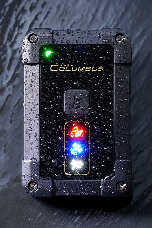
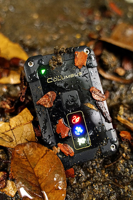
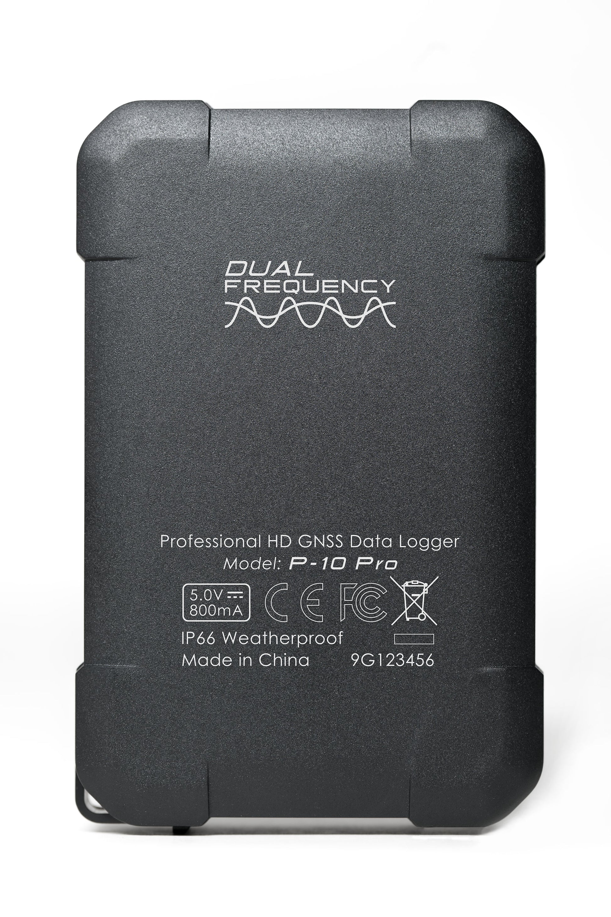
IP66 All weather
P-10 Pro can function well under all weather conditions at ease, including the icy, frosty, rainy and snowy days as well as deserts, Gobi, and the high-humidity environment!
P-10 Pro boasts an IP66 protection rating, and can be used in all weather conditions.
All connections between the buttons and the case, as well as the rubber cover at the bottom, are sealed to shield P-10 Pro from water and dust in any extreme weather.
P-10 Pro also works in an extended range of temperature from -10°C to 50°C, to ensure normal use at high latitudes and in tropical areas.

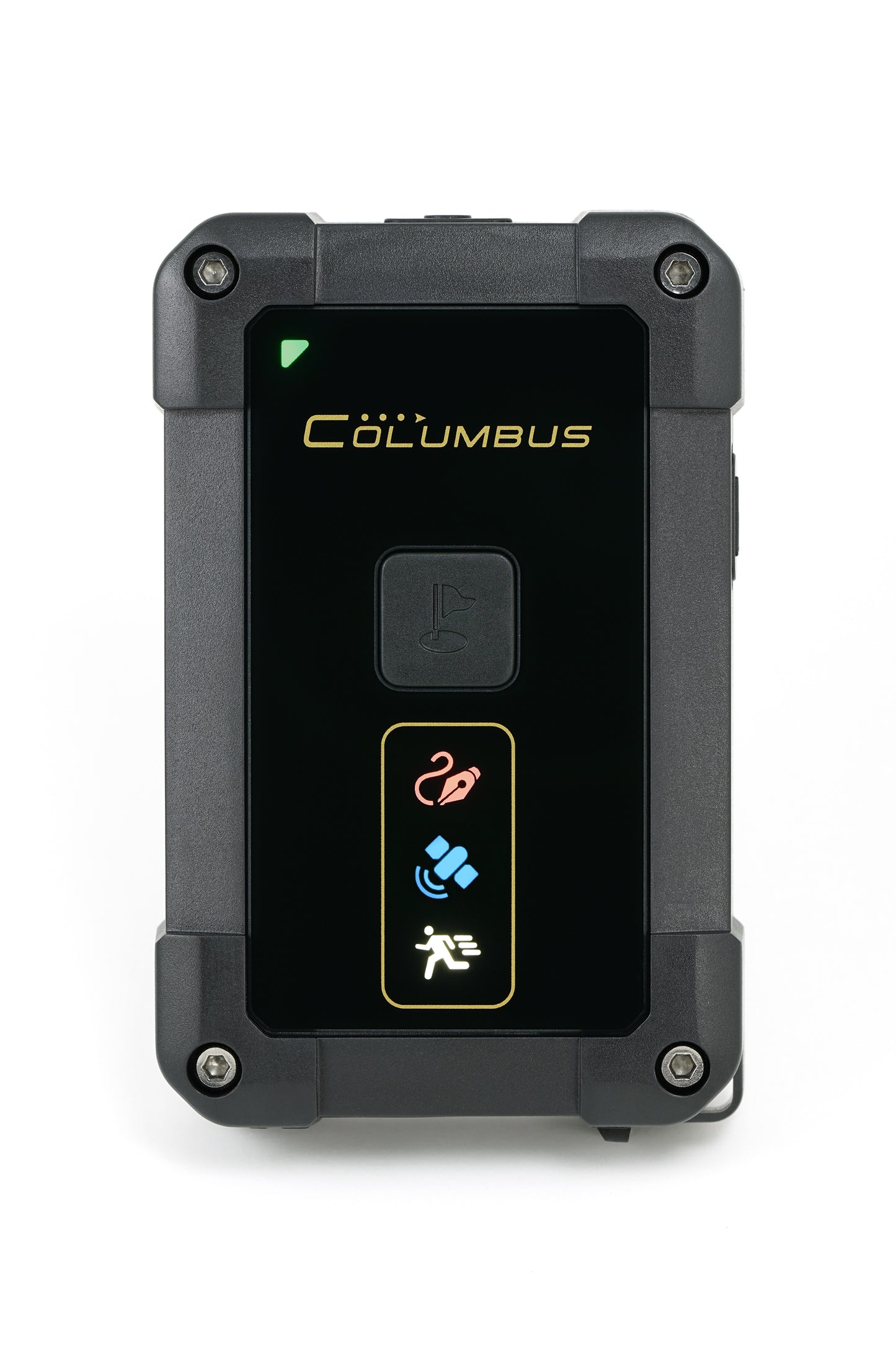
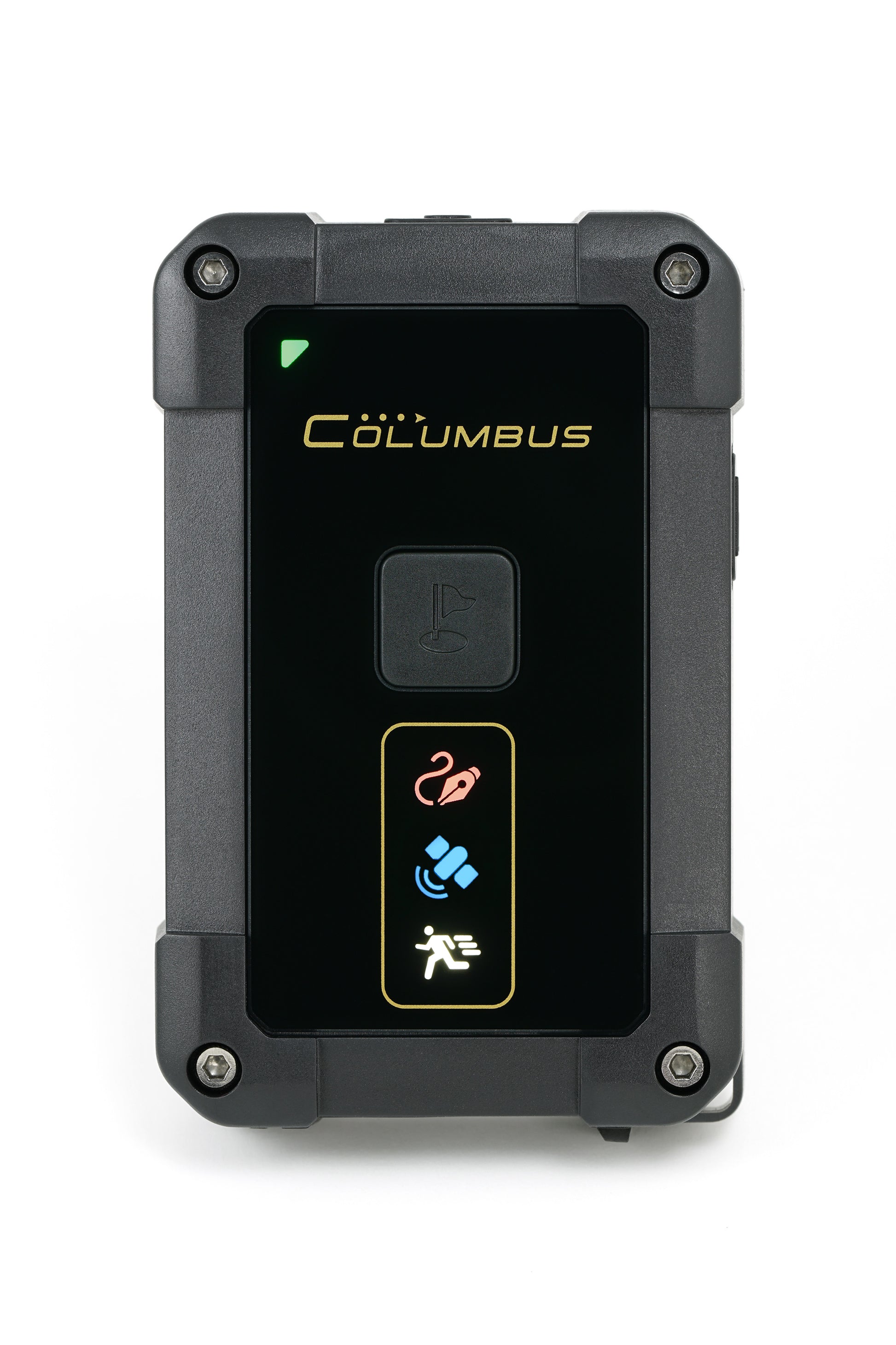
Ultra-bright multi-status lamps
We have improved the lamps design of P-10 Pro. Compared with P-1, P-10 Pro has its brightness increased by 100%, ensuring that the operating status can be clearly observed in sunlight outdoors.
HD GNSS data logger is sensitive to the environments, and the location of the device can greatly affect the positioning accuracy. In order to obtain the best accuracy, Columbus has exclusively designed the GNSS status lamp that can indicate various states for P-10 Pro.
GNSS is fixed: The lamp turns green, flashing.
GNSS is in the best positioning: The lamp turns blue, flashing.

Long battery life
The battery life of P-10 Pro is more than 50 hours*, enough for a whole week's work (10 hours a day, 5 days a week) .
*Continuous recording at 1Hz, with the ambient temperature at 20°C.

Columbus invented the Motion Detection Mode on the V-990 in 2011 and is widely welcomed by users.
The ordinary data logger still works after suspended movement or positioning failure, which consumes power and generates redundant track points. When P-10 Pro is in a static status or has lost the satellite signal for over 5 minutes, it is automatically on standby to save energy.
The Motion Detection Mode extends battery life and optimizes data. Short press the power button to turn on or off the mode.
![]()
On-board Auto on/off
P-10 Pro is automatically powered on/off with the vehicle, no need for manual operation.
*This function needs to be turned on in the configuration file.
![]()
Spy Tracking Mode
Columbus invented the Spy Tracking Mode for ultra-long battery life.
This mode achieves ultra-long battery life (up to 24 days) by interval work, and is suitable for tracking vehicles or people when charging is not convenient.In this mode, P-10 Pro gets positioned and logs 8 track points at a certain time interval.
In actual use, the spy tracking mode can not only extend the battery life but also optimize the track data.
Click to view the interval time / battery life table>
Click to learn the application case for livestock>

Personalized configuration
P-10 Pro is a professional data logger that can be customized. You can configure the following parameters at any time according to the needs of the project.
Click to learn more>

Firmware customizable and self-updated
We are constantly improving P-10 Pro. You can download the latest version of the firmware on the official website and update it by yourself to ensure that the device is in the best condition. The update is user-friendly.
In addition, you can also tell us special requirements by email (columbusgps@hotmail.com), and we can customize the special version of the firmware accordingly.
Product Specification:
Size and Weight Size: 3.3" x 2.2" x 0.7" Weight: 82g / 2.9oz

Ingress Protection*
IP66
* The rubber connector cover must be fully covered. P-10 Pro can work normally in rain, snow and high dust environments. Do not immerse P-10 Pro in water.
Operating Temperature
-10°C to 50°C / 14°F to 122°F
GNSS Performance
1575.42Mhz (L1, C/A code)
1176.45Mhz (L5)
GPS (L1+L5), GLONASS(L1), Galileo (E1+E5a), QZSS (L1+L5), BeiDou(B1), IRNSS (L5), SBAS
Built-in dual active antennas
Positioning Ability*
Cold start: <34 seconds
Warm start: <30 seconds
Hot start : <2 seconds
Horizontal position accuracy: 0.5m/CEP(50%), 1.5m/CEP(95%)
Vertical position accuracy: ±15m
* Support "EPS Pro" technology
Storage Card
MicroSD, MicroSDHC, MicroSDXC
FAT16, FAT32 file format.
Logging Data
Geodesics WGS-84
Type of track point
Date, Time
HDOP, Satellite view / used
Latitude: (0.0000001 degree)
Longitude: (0.0000001 degree)
Altitude: -1,000 ~ 18,000 meters -3280 ~ 59000 ft (1 meters / 3ft)
Speed: 0 ~ 1,850 km/h; 0~1180 mi/h (0.1km / 0.1mi)
Heading: 0 ~ 359 (1 degree)
TrackPoints Amount*
- CSV (plain code format): 550 Million points
- GPX (common exchange format): 300 Million points
- NMEA (NMEA-0183): 200 Million points
* Use 32GB MicroSD. Track points amount is an approximate value and may slightly vary from different conditions.
Dependability*
Better than 99.998%*
* Based on our test results. Way points are lost at a probability of less than 0.002%, or no more than 1 out of every 50,000 records.
Power and Battery
Built-in 2000mAh rechargeable lithium-polymer battery
Normal Mode*: 50 hours
Spy Tracking Mode: Approx 12 days (2 minutes interval); Approx 17 days (5 minutes interval); Approx 20 days (10 minutes interval); Approx 24 days (20 minutes interval)
Charging time: Approx 3.5 hours
Power supplies: DC 5V 800mA
* Continuous logging at 1Hz and 20°C environmental temperature.
System Requirements
Mac: OS X v10.7 or later
PC: Windows 7 or later
Linux: 2.6.12 or later
Parts Description

Packing List
P-10 Pro Professional HD GNSS Data Logger
MicroUSB cable
Carrying strap
Quick start
TimeAlbum™ Pro
"TimeAlbum™ Pro" is equipped with the most advanced track editing function and personalized settings with the ability to provide the latest and multiple maps, such as Google and Openstreetmap.
"TimeAlbum™ Pro" can assist in your background work, and can efficiently convert, manage and plan the tracks.
It is compatible with Windows, Linux and Mac OS.

Time Album pro software
- Over 14 map patterns to view the tracks: Google Maps, Google Satellite, OSM Map, OSM Contour Map, etc.
- Provides four commonly used statistical charts to analyze track data: time-speed, time-altitude, distance-speed, distance-altitude.
- Brand-new track list model to show information of tracking data.
- Brand-new display of tracks which includes: special points such as start point and end point of tracks, POI point, photo point, voice point (V-900/V-990 recording) and P point (parking point).
- It is allowed to personalize settings on checking, editing and converting of the tracks.
- Supports over 20 GPS track file formats, as well as formats converting of most common GPS data logger in market.
- Upgraded Geotagging. The Geotagging and view are more convenient, and you can view the shooting location and EXIF information directly on the map.
- You can add GPS coordinates on the EXIF information of the digital photo, which supports most common models of digital cameras in the market.
- Additional function: automatic correction of deviation problem of Google Maps and Google Satellite in Mainland China.
- Supports 16 languages.
- Supports the whole series of Columbus GPS data logger: V-900, V-990 ,V-1000 and P-1.
- Easy to install with cross-platform and extensive compatibility: Windows, Linux and Mac OS.
- Supports statute, nautic and metric.
Product Resources
Official Documents:
YouTube Videos:
Software Downloads:
Firmware Downloads:
Sample Data Downloads:
How to Articles and Blogs:
-
 How to connect a GPS/GNSS Receiver to Google Earth on Windows?
-
Exploring the 5Hz Logging Mode on the Columbus P-10 Pro
-
The most detailed explanation of P-10 Pro accuracy
-
How to Record Tracks Using a MicroSD Card (64G and Above) on P-10 Pro?
-
MicroSD Card Compatibility Issues Causing P-10 Pro unexpected Shutdown: Symptoms and Solutions
Tech Support Topics and Forums:
-
 How to fix the "freeze" issue when updating the firmware of Columbus P-10 Pro?
-
How to Record Tracks Using a MicroSD Card (64G and Above) on P-10 Pro?
-
Why is the P-10 Pro experiencing reduced accuracy when tested with certain apps?
-
Why am I hearing 5 short beeps instead of 1 long beep when configuring the P-10 Pro?
-
How to get a high accuracy GPS track?
-
Comparing High Accuracy GNSS Positioning Technologies: RTK vs. Dual-Frequency
-
Columbus P-10 Pro firmware update and factory reset instructions
-
How to fix the "freeze" issue when updating the firmware of Columbus P-10 Pro?
-
How to Address the Columbus P10 Pro Boot Failure Issue Following a Firmware Upgrade?