

Columbus
Columbus EX-1 Ultra-High Accuracy RTK GNSS Data Logger (Supports RTK, PPK, and standalone data logging; 30 cm accuracy in standalone mode; up to 1 cm accuracy with RTK or PPK)
Columbus EX-1 Ultra-High Accuracy RTK GNSS Data Logger (Supports RTK, PPK, and standalone data logging; 30 cm accuracy in standalone mode; up to 1 cm accuracy with RTK or PPK)
Country of Origin: China
Couldn't load pickup availability
The Columbus EX-1 is an ultra-high accuracy RTK GNSS data logger built around the u-blox ZED-F9P module. It records RTK, PPK, and standalone tracks at up to 10 Hz, delivering up to 1.0 cm accuracy with RTK or PPK and about 30 cm in standalone SBAS mode.
With dual-frequency multi-constellation reception, microSD storage over 2 TB, Bluetooth and USB-C connectivity, and four operating modes—Standalone, RTK Rover, RTK Base, and PPK—the EX-1 is designed for professional surveying, mapping, and field data collection.
Up to 1.0 cm RTK/PPK · Dual-frequency L1/L2 · ZED-F9P · microSD >2 TB · USB-C + Bluetooth · Rover, Base & PPK modes
Key Features

Ultra-High Positioning Accuracy
- Powered by u-blox ZED-F9P RTK module
- RTK: 0.01 m + 1 ppm horizontal · 0.01 m + 1 ppm vertical
- Standalone SBAS: 0.3 m (CEP)

→ Pinpoint locations as precisely as the size of a coin

Dual-Frequency, All-Constellation
- GPS · Galileo · BeiDou · GLONASS · QZSS
- Simultaneous L1 and L2 band reception
- 184 channels for reliable multi-constellation tracking
→ Dual-frequency reception helps mitigate atmospheric delay
Advanced Data Logging
- Update rates up to 10 Hz
- RTK: NMEA 0183 v4.11
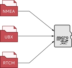
- PPK: UBX raw + RTCM 10403.3
- Standalone: NMEA positioning logs
→ One logger for real-time RTK and post-processed PPK workflows

Huge Logging Capacity
- microSD / SDHC / SDXC with exFAT support
- Capacity supported: >2 TB
- Card storage is optional—use it when you need it
→ Practical storage headroom for long field sessions

USB-C & Dual Bluetooth Channels
- USB-C Data Port for download, NTRIP upload, and configuration
- Bluetooth NTRIP SPP (upload & download)
- Bluetooth SPP (download only)
- Extension BLE channels for iOS and Android apps
→ Flexible wired and wireless links for phones, PCs, and apps

Aluminum Alloy Housing
- CNC-machined, anodized aluminum alloy body
- Protects the GNSS engine board in field use
- 4 × M3 mounting holes for secure installation
→ Durable housing with stable mounting points

Premium Dual-Feed Active Antenna
- High-gain dual-feed, dual-layer ceramic patch antenna
- Stable phase center for centimeter-level work
- IP67-rated for all-weather outdoor use
→ Outdoor-ready antenna matched to survey-grade accuracy

Professional Quality, Accessible Price
- Survey-grade RTK/PPK capability
- Designed for scalable deployment
- Strong value for mapping, surveying, and field logging
→ High-accuracy logging without a premium-only budget
Positioning Accuracy
RTK Mode
- Horizontal: 0.01 m + 1 ppm* (CEP)
- Vertical: 0.01 m + 1 ppm* (Median)
- Velocity: 0.05 m/s
- Dynamic Heading: 0.3°
Standalone SBAS Mode
- Accuracy: 0.3 m* (CEP)
* RTK figures measured with a 1 km baseline; ppm applies up to a 20 km baseline. Velocity and dynamic heading accuracy are based on 50% accuracy at 30 m/s during dynamic operation. SBAS accuracy is based on a 1-hour observation.

Operating Modes
Four modes cover standalone logging, real-time RTK, base streaming, and offline PPK collection.
1. Standalone Mode

- Operates as a standalone GNSS receiver and data logger
- Independent logging—no internet, smartphone, or computer required
- Data saved to the microSD card
- About 30 cm accuracy in standalone use
2. RTK Rover Mode

- Functions as both an RTK GNSS receiver and a data logger
- Connect to an Android or Windows device to receive CORS / NTRIP corrections
- Achieve up to 1 cm accuracy for real-time positioning and track logging
3. RTK Base Mode

4. PPK Mode

- Requires two EX-1 devices recording simultaneously (one base, one or more rovers)
- Ideal for fieldwork, offline tasks, or sites without internet access
- During collection: antenna + storage card only—no phone or PC required
- After collection, post-process on a computer for track accuracy up to 1 cm CEP
Logging Reliability
The EX-1 is designed for continuous high-volume recording. Columbus validates 24-hour continuous logging at maximum data volume with fewer than one bad data point—even while recording NMEA, RTCM, and UBX (RAW) simultaneously at 10 Hz.
→ Built for long, dense logging sessions without fragile storage workflows
Connection Channels
Three Primary Channels

USB-C — Data Port (Upload & Download): Download position data, upload NTRIP corrections, and configure device parameters.

Bluetooth — NTRIP SPP (Upload & Download): Download position data or upload NTRIP data over Serial Port Profile.
Bluetooth — SPP (Download Only): Download position data from the EX-1. SPP is widely supported on Windows and Android.
Three Extension Channels
Reserved for future hardware and app expansion as new peripherals become available.

USB-C — Link Port: For future peripherals such as an LTE modem.

Bluetooth — NTRIP BLE: App-level Bluetooth for direct interaction with iOS and Android apps.
Bluetooth — BLE: App-level Bluetooth connectivity for a range of iOS and Android apps.
Accuracy Tests
Field tests under clear-sky conditions. See the EX-1 field test topic for detailed methods and downloads.
1. RTK Rover Mode — Static Test


Demonstrated pinpoint precision with a CEP (50%) of 0.002633 m—better than the nominal 0.01 m specification.
2. RTK Rover Mode — Dynamic Test

Maintained accuracy even at ultra-low speeds, tracing a 20 cm radius path.
3. RTK Rover Mode — Dynamic Stability Test


Consistently tracked within a 1 cm margin over multiple laps.
4. Standalone Mode — Static Test


CEP (50%) accuracy was 0.240130 m, better than the nominal 0.3 m standalone specification.
Technical Specifications
Protection & Environment
| External Active GNSS Antenna | IP67 |
| EX-1 Body | Not waterproof |
| Operating Temperature | -20 °C to 50 °C / -4 °F to 122 °F |
GNSS Engine
| Module | u-blox ZED-F9P |
| Channels | 184 |
GNSS Bands — Upper L-Band (L1)
| GPS | L1C/A · 1575.42 MHz |
| Galileo | E1B/C · 1575.42 MHz |
| BeiDou | B1I · 1561.098 MHz |
| GLONASS | L1OF · 1602 MHz |
| QZSS | L1C/A, L1S · 1575.42 MHz |
| SBAS | L1C/A |
GNSS Bands — Lower L-Band (L2)
| GPS | L2C · 1227.6 MHz |
| Galileo | E5b · 1207.14 MHz |
| BeiDou | B2I · 1207.14 MHz |
| GLONASS | L2OF · 1247 MHz |
| QZSS | L2C · 1227.6 MHz |
Positioning Accuracy
| RTK Horizontal | 0.01 m + 1 ppm* (CEP) |
| RTK Vertical | 0.01 m + 1 ppm* (Median) |
| Standalone SBAS | 0.3 m (CEP 50%)** |
| Notes | * 1 km baseline; ppm limited to 20 km max baseline. ** Based on a 1-hour static test. Clear-sky test conditions. |
Measurable Range
| Maximum Altitude | 80,000 m |
| Maximum Horizontal Speed | 1,800 km/h |
| Maximum Vertical Speed | 72,000 km/h |
Acquisition & Sensitivity
| Reacquisition | < 2 s |
| Hot Start | < 2 s |
| Cold Start | < 29 s |
| RTK Convergence | < 5 s |
| Tracking & Navigation | -167 dBm |
| Reacquisition Sensitivity | -160 dBm |
| Hot Start Sensitivity | -157 dBm |
| Cold Start Sensitivity | -148 dBm |
Update Rate & Recordable Data
| Update Rate | 1, 5, 10 Hz |
| NMEA 0183 | v4.11 · Default: GNRMC, GNGGA, GNGSA, GNGSV · WGS84 |
| UBX (Default) | UBX-RXM-SFRBX · UBX-RXM-MEASX · UBX-RXM-RAWX |
| RTCM (Default) | TYPE1005, 1074, 1084, 1094, 1124, 1230 · RTCM 10403.3 |
Storage Card
| Card Types | MicroSD, MicroSDHC, MicroSDXC |
| File System | FAT16, FAT32, exFAT |
| Capacity Supported | > 2 TB |
Bluetooth
| Channel 1 | EX-1 NTRIP · SPP 2.1 · BLE 5.1 · Range > 10 m (33 ft) |
| Channel 2 | EX-1 · SPP 2.1 · BLE 5.1 · Range > 10 m (33 ft) |
Connectors
| Data Port | USB Type-C |
| Expansion / Link Port | USB Type-C |
| GNSS Antenna | SMA (Female) |
| Bluetooth Antenna | SMA (Female) |
Power and Battery
| Battery | Built-in 2100 mAh rechargeable Li-Po |
| Continuous Recording (RTK) | 10 hours* |
| Charging Time | Approx. 4.0 hours |
| Power Supply | DC 5 V 800 mA |
| Note | * Continuous logging at 1 Hz and 20 °C ambient temperature |
GNSS Antenna
| Type | Active antenna · RHCP |
| Impedance / VSWR | 50 Ω · ≤ 2.0 |
| Patch / LNA Gain | ≥ 2 dBi · 28±2 dB |
| Noise Figure | ≤ 1.5 dB |
| Connector / Cable | SMA (Male) · RG316 · 300 cm |
| Power | 3.3 V · 40 mA |
| Mounting | Magnetic with adhesive |
Bluetooth Antenna
| Type | Passive antenna |
| Frequency | 2.4–2.5 GHz |
| Polarization / Impedance | Vertical · 50 Ω |
| VSWR | ≤ 1.5 |
| Connector | SMA (Male) |
System Requirements
| Windows | Windows 7 or later |
| macOS | Mac OS X v10.10 or later |
| Linux | Kernel 2.6.12 or later |
| iOS / iPadOS | 15 or later |
| Android | Android 10 or later |
Certificates
| Compliance | FCC · CE · RoHS |
Size and Weight


Part Description

What's in the Box
- EX-1 Professional RTK GNSS Data Logger
- GNSS Antenna
- Bluetooth Transmit Antenna × 2
- USB Cable
- Warranty Card
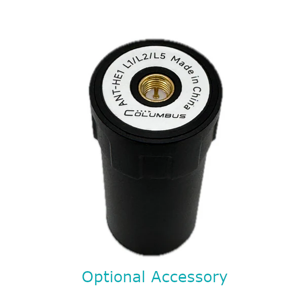
- Helical Antenna Kit (Optional)
Use EX-1 on iPhone & iPad
Pair the Columbus EX-1 with the free GeoAstra BLE-GNSS iOS app to run RTK workflows, share receiver NMEA with other apps on the same device, and collect field data from iPhone or iPad.
GeoAstra BLE-GNSS is the software bridge that brings a compatible BLE GNSS receiver—such as EX-1—onto iOS. Positions shown and recorded in the app come from the connected receiver, not from the built-in iPhone/iPad GPS.

Centimeter-Level RTK on iOS
Connect EX-1 over Bluetooth, feed NTRIP corrections, and turn your iPhone or iPad into a mobile centimeter-level RTK Rover field solution.
Local NMEA Server
Share the receiver’s NMEA stream with other iOS apps that support TCP/UDP NMEA clients—on the same device (for example QField or ArcGIS Survey123).
Collect, Stakeout & Export
Use the app’s own projects, points, tracks, stakeout and export tools when you want a complete workflow without a third-party field app.
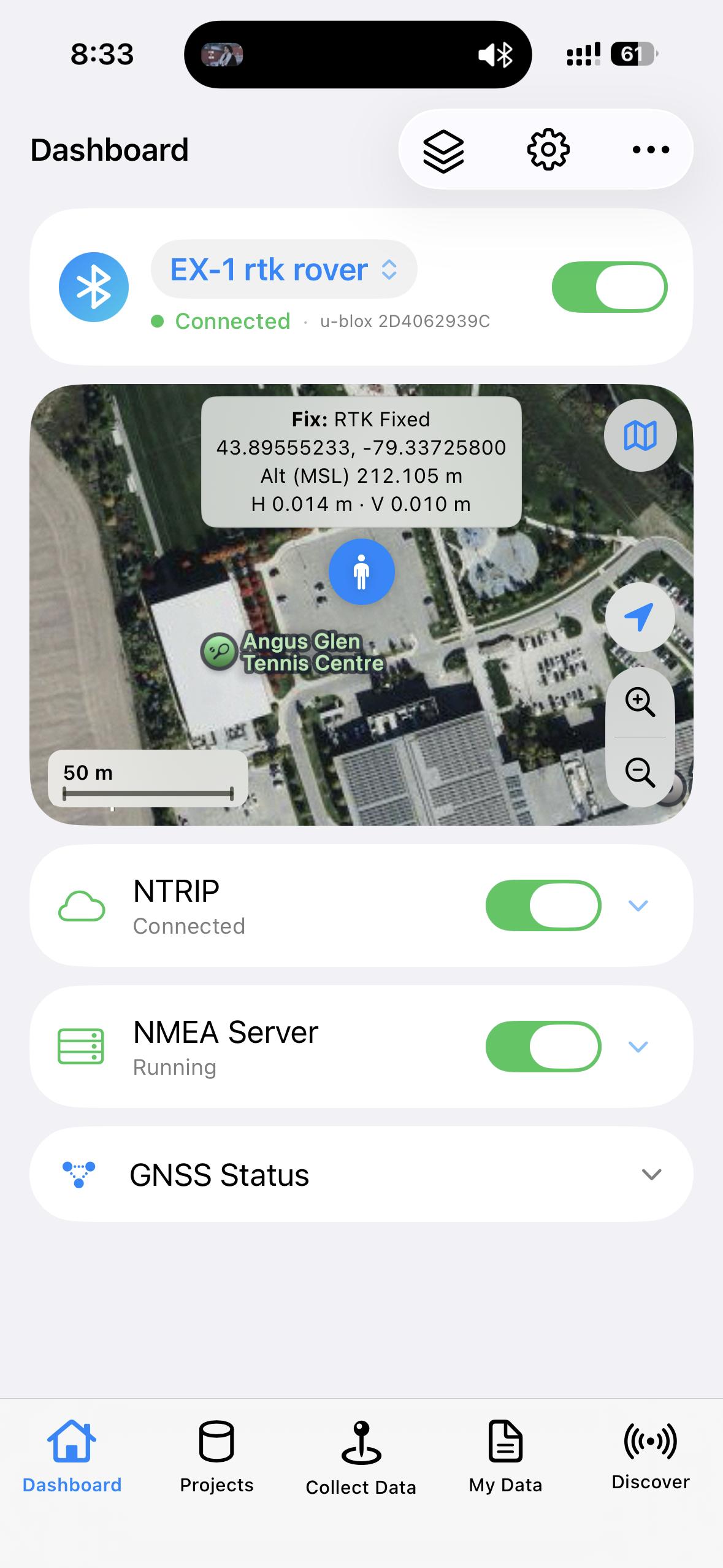
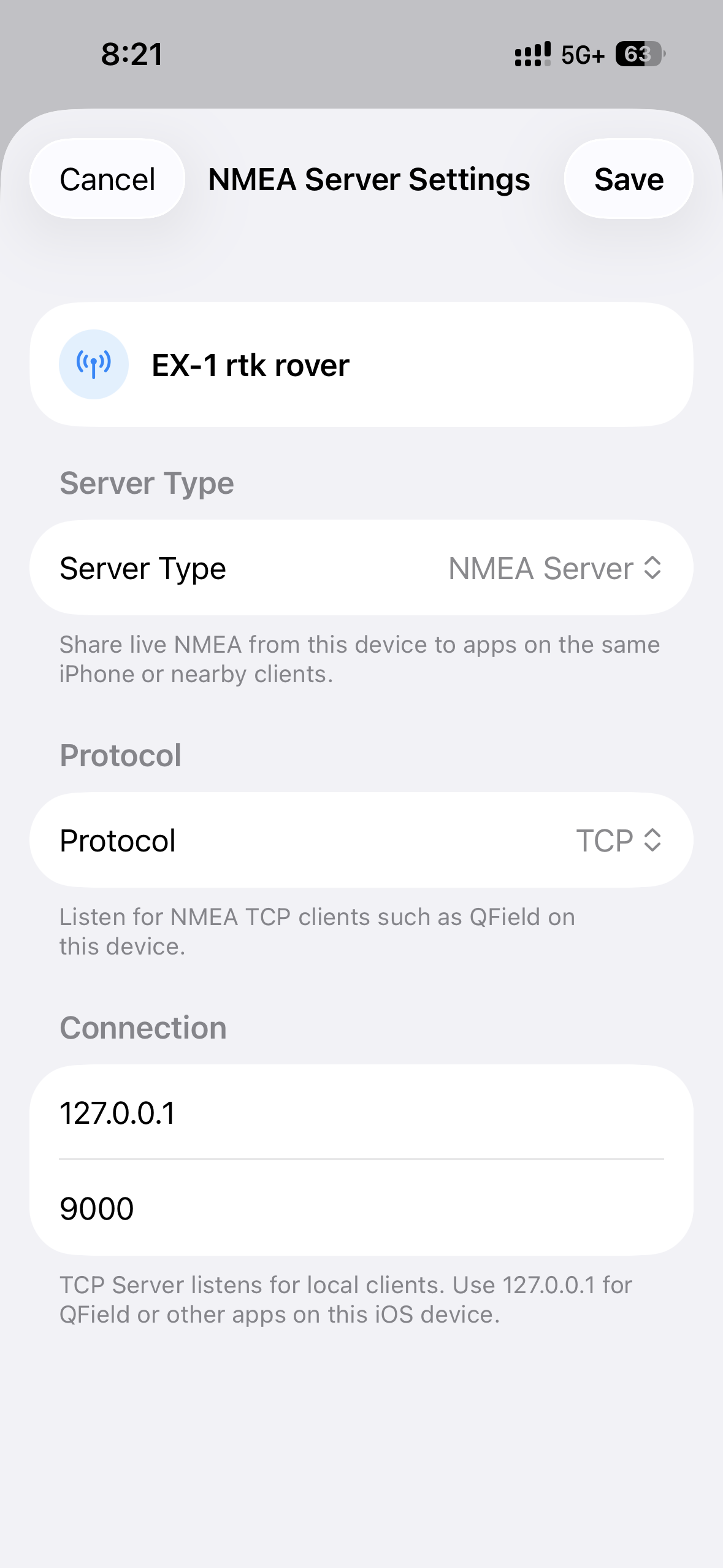
Want the full feature list, compatible-receiver notes and setup details? See the GeoAstra BLE-GNSS iOS App product page.
Time Album Pro Software
Time Album Pro is Columbus’s free desktop application for reviewing, editing, converting, and analyzing track data from Columbus GNSS data loggers. Open EX-1 NMEA, GPX, or other supported track files on a map, compare sessions with speed and altitude charts, and export to common GPS formats for further analysis.
- 14+ map styles, including Google Maps, Google Satellite, and OpenStreetMap
- Speed and altitude charts: time–speed, time–altitude, distance–speed, distance–altitude
- Track editing, conversion across 20+ GPS formats, and photo geotagging
- Windows, macOS (Apple Silicon and Intel), and Linux

Download Time Album Pro v3.6
Updated Aug 23, 2026. Linux builds require Java 17. Downloads are hosted on the official Columbus site (cbgps.com).
Product Resources
Official Documents


YouTube Videos

Downloads
Driver Downloads
- Windows 10 / 11 driver installation guide
- GNSS Sensor Device driver for Windows 10 / 11
- Linux driver installation guide
- Android connection instruction


Tool Downloads
How-to Articles and Blogs
RTK Rover
- How to connect a GPS/GNSS Receiver to Google Earth on Windows?
- How to use a RTK GNSS Receiver for Android: A Step-by-Step Guide
- Utilizing a USB/Bluetooth RTK GNSS Receiver with a Windows 10/11 Laptop: A Step-by-Step Guide
- How to Connect a USB/Bluetooth RTK GNSS Receiver to Windows? (Accessing NTRIP Through an Android Phone’s Internet Connection)
- Utilizing a RTK GNSS Receiver for Linux: A Step-by-Step Guide
- Utilizing a USB/Bluetooth RTK GNSS Receiver for High Accuracy Data Logging: A Step-by-Step Guide
- Uninstall “Windows Location Sensor”: A Step-by-Step Guide
- How to connect a GNSS Receiver to Windows Maps (or Windows Location Service)?
- NTRIP RTK products buyers’ guide

RTK Base
- PPK (Post-Processed Kinematic) by using the Columbus EX-1 GNSS Data Logger
- How to configure the Columbus EX-1 as an RTK/PPK Base Station in a Production Environment
- Build your very own NTRIP RTK Base with just an RTK GNSS Receiver and 5 minutes
- How to obtain a highly accurate coordinate for your RTK base station using PPP method?
- RTK / PPK Base Station Accuracy: Long-Duration Survey-In vs. PPP (Precise Point Positioning)
- How to setup an RTK Base station using a USB / Bluetooth RTK GNSS Receiver?
- The Free NTRIP Caster from GPSWebShop
- NTRIP RTK products buyers’ guide
- NTRIP Casters in the Real World
- How accurate does your RTK base need to be?