
ByNav
ByNav M21 RTK/IMU GNSS Module (Deeply-coupled GNSS/IMU, Triple-band L1, L2 and L5, 1507 Channels, 1cm accuracy)
ByNav M21 RTK/IMU GNSS Module (Deeply-coupled GNSS/IMU, Triple-band L1, L2 and L5, 1507 Channels, 1cm accuracy)
Country of Origin: China
Couldn't load pickup availability
The Bynav M21 is a compact, high-precision combined navigation module designed for demanding applications such as autonomous driving, tilt measurement, precision agriculture, and intelligent robotics. Featuring a deeply-coupled GNSS/IMU algorithm, a functional safety processor, and robust anti-jamming capabilities, the M21 delivers continuous, reliable, and real-time centimeter-level positioning and attitude information even in challenging environments.
Features:
1. Deeply-Coupled Combined Navigation Algorithm
Built-in MEMS IMU enables dead-reckoning (DR) calculations, ensuring continuous high-precision positioning and velocity outputs, even with brief satellite signal occlusion. The deeply-coupled algorithm, powered by the Bynav Alice SoC, significantly improves GNSS observation quality—offering 2 to 5 times better accuracy than loosely coupled solutions in environments like urban canyons.
2. Full Constellation & Frequency GNSS
Supports BDS/GPS/GLONASS/Galileo/QZSS/NavIC with full-frequency high-precision RTK. The integrated Bynav REAL (Ransac Enhanced Advanced Location) engine includes integrity monitoring to handle multipath and interference, improving fixed solution rates in urban areas for more stable and accurate results.
3. High-Performance Multiple Interference Suppression*
The built-in SAIF (Smart Advanced Interference Defense) technology utilizes high AD quantization bits to counter common interference types—single-frequency, multitone, sweeping, pulse, narrowband—with an interference-signal ratio up to 65 dBc. This greatly enhances positioning availability and integrity under complex electromagnetic conditions.
4. L-Band, CLAS, B2b (PPP), and E6 (HAS) Support**
Receives L-Band SBAS signals for high-precision positioning in regions lacking differential services or mobile networks. It also supports BeiDou-3 B2b PPP* and Galileo E6 HAS*, leveraging four-frequency signals to reduce PPP convergence time and boost high-precision availability.
Tech Advantages
• 22nm Process GNSS SoC (Alice) with 1507 Channels
Ensures robust satellite tracking and high-performance RTK positioning, covering multiple constellations and frequencies.
• Deeply-Coupled GNSS/IMU
Delivers superior navigation accuracy in signal-degraded environments through sensor fusion and advanced algorithms.
• Built-In High-Precision Functional-Safety IMU
Calibrated across the full temperature range for consistent performance in varying environmental conditions.
• Advanced Anti-Jamming Capability*
Can effectively mitigate narrowband interference at 65 dBc, improving reliability in dense urban settings and harsh electromagnetic environments.
• Flexible Interfaces & SDK
Supports UART, SPI*, CAN FD, PPS, RMII, gPTP time synchronization, and an Ethernet port. Offers an embedded SDK for differential account management and OTA upgrades.
• System Self-Check & Fault Diagnosis*
Supports safety standards such as IATF 16949*, ISO 26262 ASIL B*, and AEC-Q104* for critical applications.
Technical Spec:
GNSS Performance
• Constellations: GPS, BDS, GLONASS, Galileo, QZSS, NavIC
• Number of Channels: 1507
• GNSS Bands:
• L-Band* (3 channels, 1525–1559 MHz)
• BDS-2: B1I, B2I, B3I
• BDS-3: B1I, B1C*, B2a, B2b (PPP)*, B3I
• GPS: L1 C/A, L1C*, L2, L5
• GLONASS: G1, G2
• Galileo: E1, E5a, E5b, E6 (HAS)*
• QZSS: L1 C/A, L1C, L2, L5, L6 (CLAS)*
• NavIC: L5
• SBAS*: L1 C/A
• Anti-jamming*: Single-frequency, multitone, sweeping, pulse, narrowband (up to 65 dBc)
Positioning Accuracy (RMS)¹ ²
• Horizontal:
• Single Point: 1.5 m
• RTK: 1.0 cm + 1 ppm
• Vertical:
• Single Point: 2.5 m
• RTK: 1.5 cm + 1 ppm
Output Rate
• GNSS Observation⁹: 10 Hz
• GNSS Positioning Result⁹: 5 Hz
• INS Positioning Result: 100 Hz
• IMU Raw Data: 100 Hz
• Dead Reckoning Accuracy (2σ)¹¹: 0.8%
Time to First Fix
• Cold Start³ ⁵: 30 s
• Hot Start⁴ ⁵: 5 s
• RTK Initialization¹: 5 s
• Re-acquisition: ≤ 1 s
Additional Accuracy
• Timing Accuracy (RMS)⁷: ≤ 20 ns
• Velocity Accuracy⁶: 0.03 m/s
• RTK Solution Delay: 50 ms
IMU Performance
Gyroscope
• Range: ±300 °/s
• Bias Instability: 5 °/h
• Bias Over Temperature: 0.3 °/s
Accelerometer
• Range: ±16 g
• Bias Instability: 50 µg
• Bias Over Temperature: 5 mg
Environment & Certification
• Operating Temperature¹⁰: -40 ℃ ~ +85 ℃
• Storage Temperature: -40 ℃ ~ +105 ℃
• Humidity: 95% (Non-condensing)
• Vibration: JESD22-B103
• Shock: JESD22-B110
• IATF 16949*, ISO 26262 ASIL B*, AEC-Q104*
Mechanical & Electrical
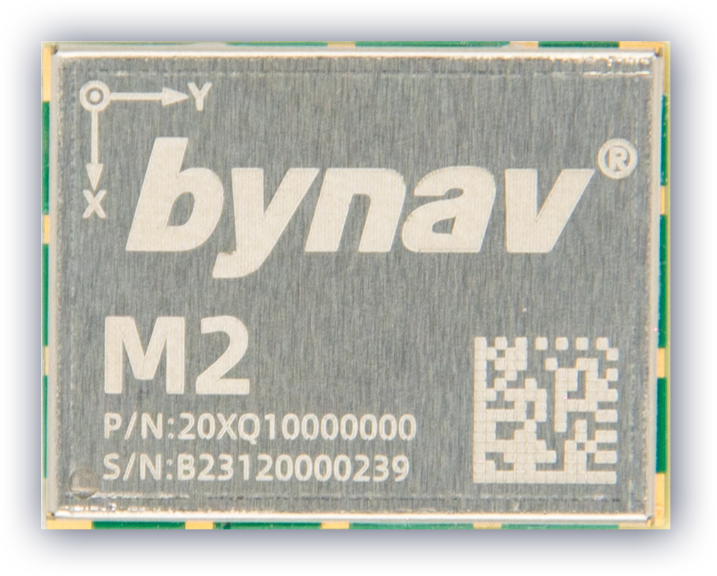
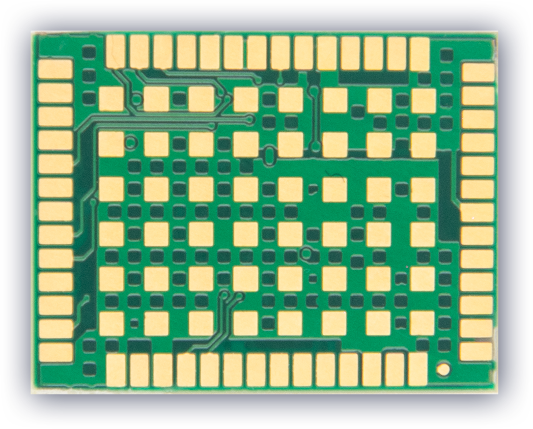
• Dimensions: 17.0 × 22.0 × 2.75 mm (54-pin LGA)
• Weight: 2.05 g
• Power Consumption⁸: 500 mW (excluding antenna and peripherals)
• Power Supply Range: 3.15 ~ 3.45 V
Notes
1. Typical value. Performance is affected by GNSS signal quality, satellite geometry, baseline length, multipath, and other interference factors.
2. Based on a 1 km baseline and a receiver with a good antenna, without considering possible errors from antenna phase center offset.
3. Typical value. Time from power-on to the first valid single-point position output after clearing ephemeris/almanac/coarse position/time information.
4. Typical value. Time from power-on to the first valid single-point position output when the receiver has stored valid ephemeris/almanac/coarse position and relatively accurate time (error < 5 minutes). The special firmware supports a 3-second hot start but does not support the network port.
5. Requires -130 dBm signal strength and at least 12 available satellites.
6. Under open sky with no obstruction, 99% @ static condition.
7. Optional. RF and antenna biases are not included.
8. Typical value, excludes power for antenna and peripherals.
9. 10 Hz is supported in special firmware.
10. -40 ℃ ~ +105 ℃ range is optional.
11. Achieved when an odometer is connected and the vehicle model is used.
Product Resources
Tech Support Topics and Forums: